IMAGES TAKEN NEAR TO
Corstorphine Road, THORNHILL, DG3 5NB
Introduction
This page details the photographs taken nearby to Corstorphine Road, DG3 5NB by members of the Geograph project.
The Geograph project started in 2005 with the aim of publishing, organising and preserving representative images for every square kilometre of Great Britain, Ireland and the Isle of Man.

There are currently over 7.5m images from over14,400 individuals and you can help contribute to the project by visiting https://www.geograph.org.uk
Image Map (Loading...)


Getting Data...Please wait
Leaflet Map data © OpenStreetMap
Images are licensed for reuse under creativecommons.org/licenses/by-sa/2.0
Notes
- Clicking on the map will re-center to the selected point.
- The higher the marker number, the further away the image location is from the centre of the postcode.
Image Listing (144 Images Found)
Images are licensed for reuse under creativecommons.org/licenses/by-sa/2.0
Image
Details
Distance
2
Freemasons Hall, Thornhill
On the east side of Drumlanrig Street, opposite the Thornhill Inn.
Image: © M J Richardson
Taken: 30 Jul 2009
0.11 miles
3
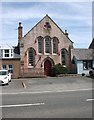
Former E U Church, South Drumlanrig Street, Thornhill
Now a squash club.
Image: © Richard Sutcliffe
Taken: 19 May 2018
0.11 miles
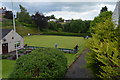
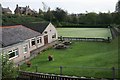
6
The bowling green, East Morton Street, Thornhill
Image: © Alan Reid
Taken: 21 Nov 2016
0.11 miles
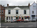
7
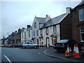
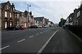
Shops on Drumlanrig Street, Thornhill
Image: © Darrin Antrobus
Taken: 8 Feb 2008
0.11 miles
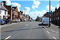
8
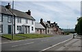
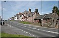
South Drumlanrig Street, Thornhill
Image: © Richard Sutcliffe
Taken: 19 May 2018
0.12 miles
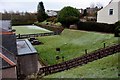
10
South Drumlanrig Street, Thornhill
Image: © Richard Sutcliffe
Taken: 19 May 2018
0.12 miles