IMAGES TAKEN NEAR TO
Closeburn, THORNHILL, DG3 5JH
Introduction
This page details the photographs taken nearby to DG3 5JH by members of the Geograph project.
The Geograph project started in 2005 with the aim of publishing, organising and preserving representative images for every square kilometre of Great Britain, Ireland and the Isle of Man.

There are currently over 7.5m images from over14,400 individuals and you can help contribute to the project by visiting https://www.geograph.org.uk
Image Map (Loading...)


Getting Data...Please wait
Leaflet Map data © OpenStreetMap
Images are licensed for reuse under creativecommons.org/licenses/by-sa/2.0
Notes
- Clicking on the map will re-center to the selected point.
- The higher the marker number, the further away the image location is from the centre of the postcode.
Image Listing (9 Images Found)
Images are licensed for reuse under creativecommons.org/licenses/by-sa/2.0
Image
Details
Distance
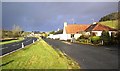
1
Near Whitespots
Photo taken from the train with an iPhone.
Image: © Darrin Antrobus
Taken: 25 May 2009
0.03 miles
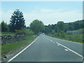
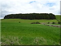
4
The Lake
Lake in this case means burn. Beside the A76.
Image: © Richard Webb
Taken: 22 Apr 2019
0.17 miles
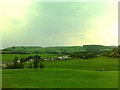
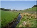
5
Grazing near Whitewalls
Looking towards the Dumfries to Carlisle Railway and a distant Axe Wood.
Image: © JThomas
Taken: 22 May 2021
0.19 miles
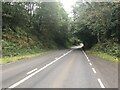
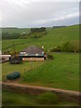
8
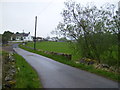
The lane just off the A76 road at Stepends
Image: © Phil Catterall
Taken: 22 Apr 2007
0.21 miles