IMAGES TAKEN NEAR TO
Closeburn, THORNHILL, DG3 5HA
Introduction
This page details the photographs taken nearby to DG3 5HA by members of the Geograph project.
The Geograph project started in 2005 with the aim of publishing, organising and preserving representative images for every square kilometre of Great Britain, Ireland and the Isle of Man.

There are currently over 7.5m images from over14,400 individuals and you can help contribute to the project by visiting https://www.geograph.org.uk
Image Map (Loading...)


Getting Data...Please wait
Leaflet Map data © OpenStreetMap
Images are licensed for reuse under creativecommons.org/licenses/by-sa/2.0
Notes
- Clicking on the map will re-center to the selected point.
- The higher the marker number, the further away the image location is from the centre of the postcode.
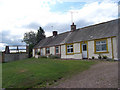
Image Listing (6 Images Found)
Images are licensed for reuse under creativecommons.org/licenses/by-sa/2.0
Image
Details
Distance
1
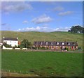
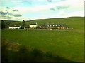
Cottages at Campleslacks
Two old railwaymen's cottages at Campleslacks
Image: © bill copland
Taken: 14 Aug 2006
0.06 miles
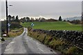
3
Minor road approaching Cample
Looking north-ward.
Image: © Peter Wood
Taken: 6 Apr 2019
0.19 miles
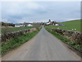
5
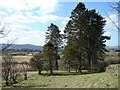
Bottom of the Strip
Approaching the western end of the wind break which runs up the hill from the road near Cample.
Image: © Ian Paterson
Taken: 17 Mar 2008
0.23 miles