IMAGES TAKEN NEAR TO
Gatelawbridge, THORNHILL, DG3 5EA
Introduction
This page details the photographs taken nearby to DG3 5EA by members of the Geograph project.
The Geograph project started in 2005 with the aim of publishing, organising and preserving representative images for every square kilometre of Great Britain, Ireland and the Isle of Man.

There are currently over 7.5m images from over14,400 individuals and you can help contribute to the project by visiting https://www.geograph.org.uk
Image Map (Loading...)


Getting Data...Please wait
Leaflet Map data © OpenStreetMap
Images are licensed for reuse under creativecommons.org/licenses/by-sa/2.0
Notes
- Clicking on the map will re-center to the selected point.
- The higher the marker number, the further away the image location is from the centre of the postcode.
Image Listing (3 Images Found)
Images are licensed for reuse under creativecommons.org/licenses/by-sa/2.0
Image
Details
Distance
1
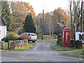
Telephone box, Gatelawbridge
This was a quarry village with one of the holes in the ground now occupied by a waste handling and recycling centre. There was a spur line off the railway at Thornhill serving the quarries.
Image: © Richard Webb
Taken: 18 Nov 2012
0.14 miles
3
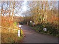
Waste handling site, Gatelawbridge
Usual collection of recycling skips in an old quarry.
Image: © Richard Webb
Taken: 18 Nov 2012
0.17 miles