IMAGES TAKEN NEAR TO
Milner Place, Coo Lane, THORNHILL, DG3 5DB
Introduction
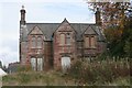
This page details the photographs taken nearby to Milner Place, Coo Lane, DG3 5DB by members of the Geograph project.
The Geograph project started in 2005 with the aim of publishing, organising and preserving representative images for every square kilometre of Great Britain, Ireland and the Isle of Man.

There are currently over 7.5m images from over14,400 individuals and you can help contribute to the project by visiting https://www.geograph.org.uk
Image Map
Images are licensed for reuse under creativecommons.org/licenses/by-sa/2.0
Notes
- Clicking on the map will re-center to the selected point.
- The higher the marker number, the further away the image location is from the centre of the postcode.
Image Listing (142 Images Found)
Images are licensed for reuse under creativecommons.org/licenses/by-sa/2.0
Image
Details
Distance
3
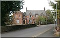
Old Morton Academy, Thornhill
This building has been replaced by a new one just across the road.
Image: © Ann Cook
Taken: 18 Sep 2013
0.08 miles
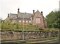
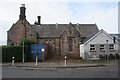
4
Former East Morton Street Primary School
Boarded up since a new primary school replaced it in 2010, this Category B listed building, together with the adjacent Caretaker's House [http://www.geograph.org.uk/photo/5167387], is currently up for sale.
Image: © Richard Sutcliffe
Taken: 21 Oct 2016
0.08 miles
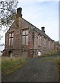
5
Former East Morton Street Primary School Caretaker's House
This Category B listed building has been unused since 2003, and together with the adjacent primary school [http://www.geograph.org.uk/photo/5167340] which has been boarded up since 2010, is currently up for sale.
Image: © Richard Sutcliffe
Taken: 21 Oct 2016
0.08 miles
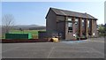
6
Viewfield, East Morton Street, Thornhill
The modern extension is part of East Morton Street Garage just out of picture. The windows in it appear to have been recently replaced.
Image: © Richard Sutcliffe
Taken: 21 Oct 2016
0.08 miles
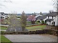
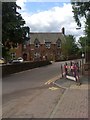
9
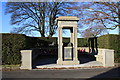
Thornhill War Memorial
Just inside the square sits Thornhill War Memorial.
Image: © Colin Kinnear
Taken: 26 Nov 2010
0.09 miles
10
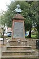
Monument to Joseph Thomson
This monument to African explorer Joseph Thomson is situated at the end of East Morton Street at the junction of Manse Road.
The south-eastern side panel reads:
ERECTED
TO
JOSEPH THOMSON
AFRICAN EXPLORER
FELLOW AND GOLD MEDALLIST
OF THE
ROYAL GEOGRAPHICAL SOCIETY
BY
MEMBERS OF THE R.G.S.
AND OTHER FRIENDS
1897
The north-western panel reads:
EXPEDITIONS
TO
LAKES NYASSA AND TANGANYIKA
1878-1880.
UP THE RIVER ROVUMA, 1881.
THROUGH MASAI-LAND
AND KAVIRONDO, 1883-1884
BY THE RIVER NIGER TO SONOTO 1885
TO MOROCCO AND THE ATLAS 1888
THROUGH BRITISH CENTRAL AFRICA
1890-1891.
Image: © Richard Sutcliffe
Taken: 21 Oct 2016
0.09 miles