IMAGES TAKEN NEAR TO
Enterkinfoot, THORNHILL, DG3 5BY
Introduction
This page details the photographs taken nearby to DG3 5BY by members of the Geograph project.
The Geograph project started in 2005 with the aim of publishing, organising and preserving representative images for every square kilometre of Great Britain, Ireland and the Isle of Man.

There are currently over 7.5m images from over14,400 individuals and you can help contribute to the project by visiting https://www.geograph.org.uk
Image Map (Loading...)


Getting Data...Please wait
Leaflet Map data © OpenStreetMap
Images are licensed for reuse under creativecommons.org/licenses/by-sa/2.0
Notes
- Clicking on the map will re-center to the selected point.
- The higher the marker number, the further away the image location is from the centre of the postcode.
Image Listing (19 Images Found)
Images are licensed for reuse under creativecommons.org/licenses/by-sa/2.0
Image
Details
Distance

5
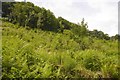
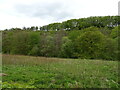
Opposite Enterkinfoot
A clearfelled slope on the west side of the Nith.
Image: © Richard Webb
Taken: 10 Jun 2018
0.08 miles
7
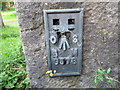
Ordnance Survey Flush Bracket G578
This can be found on the wall of Mill House at Enterkinfoot.
For more detail see : http://www.bench-marks.org.uk/bm2526
Image: © Peter Wood
Taken: 27 Sep 2013
0.10 miles
8

Enterkinfoot Viaduct
The viaduct as in 1979, before the trees grew to hide most of it. The Google Street View image https://goo.gl/maps/1ZwnD5X8yByzeVQ26 shows the viaduct almost hidden.
Image: © John Lawson
Taken: 22 Sep 1979
0.11 miles
10
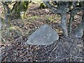
20 Miles to Dumfries
Old milestone on the other side of the road from Auchenbraith. Half-buried, knocked over, and neglected looking. 20 miles to Dumfries from here.
Photo taken on the 27th March 2022.
Image: © Rab McMurdo
Taken: 27 Mar 2022
0.12 miles