IMAGES TAKEN NEAR TO
Tynron, THORNHILL, DG3 4LA
Introduction
This page details the photographs taken nearby to DG3 4LA by members of the Geograph project.
The Geograph project started in 2005 with the aim of publishing, organising and preserving representative images for every square kilometre of Great Britain, Ireland and the Isle of Man.

There are currently over 7.5m images from over14,400 individuals and you can help contribute to the project by visiting https://www.geograph.org.uk
Image Map
Images are licensed for reuse under creativecommons.org/licenses/by-sa/2.0
Notes
- Clicking on the map will re-center to the selected point.
- The higher the marker number, the further away the image location is from the centre of the postcode.
Image Listing (30 Images Found)
Images are licensed for reuse under creativecommons.org/licenses/by-sa/2.0
Image
Details
Distance
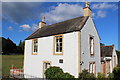
1
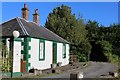
Lannhall, North Lodge
Category B-listed. Late 18th to early 19th century.
Image: © Leslie Barrie
Taken: 11 Jul 2014
0.03 miles
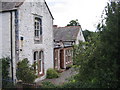
7
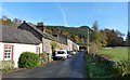
Road to Penpont, Tynron
A mixed row of terraced stone houses.
Image: © Alan Reid
Taken: 31 Oct 2010
0.17 miles
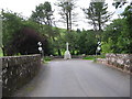
8
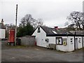
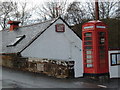
Tynron Parish Hall
The telephone box no longer has a telephone.
Image: © Richard Webb
Taken: 28 Feb 2023
0.17 miles
9
Telephone box at Tynron Parish Hall
Image: © Darrin Antrobus
Taken: 27 Feb 2008
0.18 miles
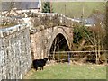
10
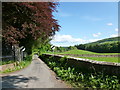
Road junction at Kirkland, Tynron
The public road ends at Linnhouse, but a track can be followed on to the main road near Shinnel Bridge.
Image: © Alan O'Dowd
Taken: 30 May 2016
0.18 miles