IMAGES TAKEN NEAR TO
Neis Place, THORNHILL, DG3 4HS
Introduction
This page details the photographs taken nearby to Neis Place, DG3 4HS by members of the Geograph project.
The Geograph project started in 2005 with the aim of publishing, organising and preserving representative images for every square kilometre of Great Britain, Ireland and the Isle of Man.

There are currently over 7.5m images from over14,400 individuals and you can help contribute to the project by visiting https://www.geograph.org.uk
Image Map (Loading...)


Getting Data...Please wait
Leaflet Map data © OpenStreetMap
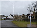
Images are licensed for reuse under creativecommons.org/licenses/by-sa/2.0
Notes
- Clicking on the map will re-center to the selected point.
- The higher the marker number, the further away the image location is from the centre of the postcode.
Image Listing (111 Images Found)
Images are licensed for reuse under creativecommons.org/licenses/by-sa/2.0
Image
Details
Distance
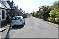
1
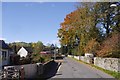
North Street, Moniaive
Bus turning area on the left, the road heads for the hills and now has a brown sign for The Striding Arches.
Image: © Richard Webb
Taken: 6 Oct 2018
0.01 miles

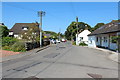
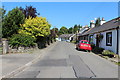
3
North Street in Moniaive
Looking north-westward
Image: © Peter Wood
Taken: 9 Sep 2017
0.03 miles
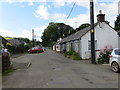
5
North Street, Moniaive
Cottages in North Street, Moniaive.
Image: © Chris Newman
Taken: 9 Mar 2008
0.06 miles
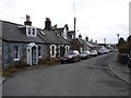
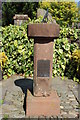
9
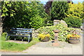
Sun Dial, Moniaive
On the corner of Park Road and North Street.
Image: © Billy McCrorie
Taken: 23 Jul 2014
0.09 miles
10
Sun Dial, Moniaive
On the corner of Park Road and North Street.
Image: © Billy McCrorie
Taken: 23 Jul 2014
0.09 miles