IMAGES TAKEN NEAR TO
Dunreggan, THORNHILL, DG3 4HQ
Introduction
This page details the photographs taken nearby to Dunreggan, DG3 4HQ by members of the Geograph project.
The Geograph project started in 2005 with the aim of publishing, organising and preserving representative images for every square kilometre of Great Britain, Ireland and the Isle of Man.

There are currently over 7.5m images from over14,400 individuals and you can help contribute to the project by visiting https://www.geograph.org.uk
Image Map
Images are licensed for reuse under creativecommons.org/licenses/by-sa/2.0
Notes
- Clicking on the map will re-center to the selected point.
- The higher the marker number, the further away the image location is from the centre of the postcode.
Image Listing (129 Images Found)
Images are licensed for reuse under creativecommons.org/licenses/by-sa/2.0
Image
Details
Distance
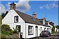
1
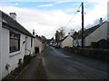
The A702 in Moniaive
Heading east for Thornhill.
Image: © David Purchase
Taken: 25 Oct 2018
0.02 miles
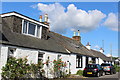
3
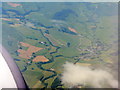
Moniaive from the northeast
Looking up the valleys of the Castlefairn and Craigdarroch Waters, the latter on the right with the B729.
Image: © M J Richardson
Taken: 7 Jul 2013
0.04 miles
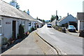
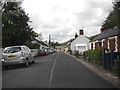
4
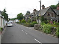
Dunreggan, Moniaive
The A702 runs through the narrow thoroughfare of Dunreggan, part of the busy village of Moniaive but separated from the centre by the Dalwhat Water.
Image: © Chris Newman
Taken: 9 Mar 2008
0.04 miles
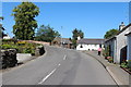
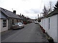
6
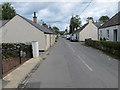
Road (A702) at Dunreggan, Moniaive
Looking south-eastward.
Image: © Peter Wood
Taken: 9 Sep 2017
0.07 miles