IMAGES TAKEN NEAR TO
Moniaive, THORNHILL, DG3 4HL
Introduction
This page details the photographs taken nearby to DG3 4HL by members of the Geograph project.
The Geograph project started in 2005 with the aim of publishing, organising and preserving representative images for every square kilometre of Great Britain, Ireland and the Isle of Man.

There are currently over 7.5m images from over14,400 individuals and you can help contribute to the project by visiting https://www.geograph.org.uk
Image Map (Loading...)


Getting Data...Please wait
Leaflet Map data © OpenStreetMap
Images are licensed for reuse under creativecommons.org/licenses/by-sa/2.0
Notes
- Clicking on the map will re-center to the selected point.
- The higher the marker number, the further away the image location is from the centre of the postcode.
Image Listing (8 Images Found)
Images are licensed for reuse under creativecommons.org/licenses/by-sa/2.0
Image
Details
Distance


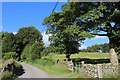
3
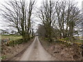
Tynron to Moniaive road
Near its summit.
Image: © Richard Webb
Taken: 28 Feb 2023
0.20 miles
5
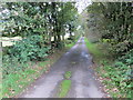
Road from Tynron to Moniaive approaching Hillhead
Looking south-westward.
Image: © Peter Wood
Taken: 9 Sep 2017
0.21 miles
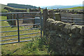
7

Sheep pen north of Moniaive
Sheep pen to the north of Moniaive.
Image: © Colin Kinnear
Taken: 17 Jun 2020
0.23 miles