IMAGES TAKEN NEAR TO
Kirkland, THORNHILL, DG3 4HB
Introduction
This page details the photographs taken nearby to Kirkland, DG3 4HB by members of the Geograph project.
The Geograph project started in 2005 with the aim of publishing, organising and preserving representative images for every square kilometre of Great Britain, Ireland and the Isle of Man.

There are currently over 7.5m images from over14,400 individuals and you can help contribute to the project by visiting https://www.geograph.org.uk
Image Map (Loading...)


Getting Data...Please wait
Leaflet Map data © OpenStreetMap
Images are licensed for reuse under creativecommons.org/licenses/by-sa/2.0
Notes
- Clicking on the map will re-center to the selected point.
- The higher the marker number, the further away the image location is from the centre of the postcode.
Image Listing (32 Images Found)
Images are licensed for reuse under creativecommons.org/licenses/by-sa/2.0
Image
Details
Distance
1
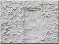
Ordnance Survey Flush Bracket G311
This can be found on the wall of Berry Cottage (formerly Gravel Pit Cottage).
For more detail see : http://www.bench-marks.org.uk/bm20247
Image: © Peter Wood
Taken: 27 Sep 2013
0.01 miles
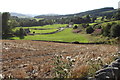
5
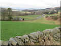
Fields at Kirkland Bridge
With Gravelpit Cottage and the B729 across the near grass field.
Image: © M J Richardson
Taken: 24 Feb 2023
0.03 miles
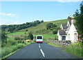
7
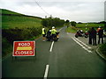
B729/A702 junction,Kirkland
Road closed for Tour of Britain cycle race
Image: © Lee Brown
Taken: 15 Sep 2007
0.04 miles
8
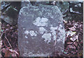
Old Milestone by the B729, south of Kirkland, Glencarn parish
Stone post by the B729, in parish of Glencarn (Nithsdale District), South of junction with the A702, on verge in front of stone wall.
Inscription once read:-
(Dumfries)
(14)
Surveyed
Milestone Society National ID: DG_DFMN14
Image: © Milestone Society
Taken: Unknown
0.05 miles
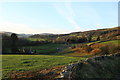
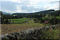
9
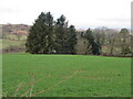
Trees at Gravelpit Cottage
Beyond a grass field and, in the distance, Castlehill Wood.
Image: © M J Richardson
Taken: 24 Feb 2023
0.06 miles
10
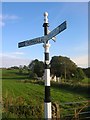
Direction sign - Signpost on the A702 east of Kirkland
Ball finial - 3 arms; by the A702, in parish of Glencairn (Dumfries District), east of Kirkland on the southeast side of the junction of the A702 Clone Road and the B729 to Dumfries.
Surveyed
Milestone Society National ID: DF_NX8190
Image: © C Minto
Taken: Unknown
0.08 miles