IMAGES TAKEN NEAR TO
Moniaive, THORNHILL, DG3 4EN
Introduction
This page details the photographs taken nearby to DG3 4EN by members of the Geograph project.
The Geograph project started in 2005 with the aim of publishing, organising and preserving representative images for every square kilometre of Great Britain, Ireland and the Isle of Man.

There are currently over 7.5m images from over14,400 individuals and you can help contribute to the project by visiting https://www.geograph.org.uk
Image Map (Loading...)


Getting Data...Please wait
Leaflet Map data © OpenStreetMap
Images are licensed for reuse under creativecommons.org/licenses/by-sa/2.0
Notes
- Clicking on the map will re-center to the selected point.
- The higher the marker number, the further away the image location is from the centre of the postcode.
Image Listing (7 Images Found)
Images are licensed for reuse under creativecommons.org/licenses/by-sa/2.0
Image
Details
Distance
4
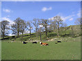
Grazing field
Viewed from the A702 near Woodlea.
Image: © Walter Baxter
Taken: 12 Apr 2007
0.15 miles
5
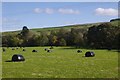
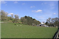
Haugh, Woodlea
Round silage bales beside the Castlefairn Water.
Image: © Richard Webb
Taken: 6 Oct 2018
0.15 miles
6
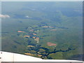
Glencrosh from the northeast
Looking up the valley of Castlefairn Water, running parallel with the Moniaive-St John's Town of Dalry road [A702]
Image: © M J Richardson
Taken: 7 Jul 2013
0.17 miles
7
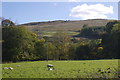
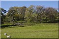
Sheep, Glencrosh
Grassland beside the Castlefairn Water.
Image: © Richard Webb
Taken: 6 Oct 2018
0.24 miles