IMAGES TAKEN NEAR TO
Tynron, THORNHILL, DG3 4DU
Introduction
This page details the photographs taken nearby to DG3 4DU by members of the Geograph project.
The Geograph project started in 2005 with the aim of publishing, organising and preserving representative images for every square kilometre of Great Britain, Ireland and the Isle of Man.

There are currently over 7.5m images from over14,400 individuals and you can help contribute to the project by visiting https://www.geograph.org.uk
Image Map (Loading...)


Getting Data...Please wait
Leaflet Map data © OpenStreetMap
Images are licensed for reuse under creativecommons.org/licenses/by-sa/2.0
Notes
- Clicking on the map will re-center to the selected point.
- The higher the marker number, the further away the image location is from the centre of the postcode.
Image Listing (5 Images Found)
Images are licensed for reuse under creativecommons.org/licenses/by-sa/2.0
Image
Details
Distance
1
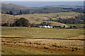
Low Lann Farm
Viewed from the east-northeast slopes of Shancastle Doon in early March.
Image: © Walter Baxter
Taken: 7 Mar 2010
0.01 miles
2

Road from A702 to Tynron at Low Lann
Looking south-eastward.
Image: © Peter Wood
Taken: 12 Sep 2017
0.01 miles
3
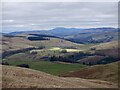
View from Auchengibbert Hill
A view to a distant Criffel with brief sunlight at Low Lann.
Image: © Richard Webb
Taken: 28 Feb 2023
0.08 miles
4

Road from A702 to Tynron to the west of Low Lann
Looking north-westward.
Image: © Peter Wood
Taken: 12 Sep 2017
0.11 miles
5
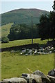
Just along from Tynron, Wauk Hill in the distance
Image: © Andrya Prescott
Taken: 19 Jul 2006
0.13 miles