IMAGES TAKEN NEAR TO
Penpont, THORNHILL, DG3 4BN
Introduction
This page details the photographs taken nearby to DG3 4BN by members of the Geograph project.
The Geograph project started in 2005 with the aim of publishing, organising and preserving representative images for every square kilometre of Great Britain, Ireland and the Isle of Man.

There are currently over 7.5m images from over14,400 individuals and you can help contribute to the project by visiting https://www.geograph.org.uk
Image Map
Images are licensed for reuse under creativecommons.org/licenses/by-sa/2.0
Notes
- Clicking on the map will re-center to the selected point.
- The higher the marker number, the further away the image location is from the centre of the postcode.
Image Listing (16 Images Found)
Images are licensed for reuse under creativecommons.org/licenses/by-sa/2.0
Image
Details
Distance
1
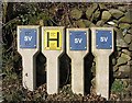
Underground services markers
By a minor road near Penpont.
Image: © Walter Baxter
Taken: 24 Mar 2007
0.11 miles
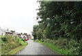
2
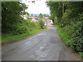
Road from Auchenbainzie descending into Penpont
Looking south-eastward.
Image: © Peter Wood
Taken: 12 Sep 2017
0.13 miles
3
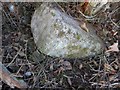
Old Milestone north of Penpont
By the UC road, in parish of Penpont (Nithsdale District), north end of Penpont, on verge.
Inscription once read:-
(Dumfries)
(16)
Surveyed
Milestone Society National ID: DG_DFSQUC15.
Image: © Milestone Society
Taken: Unknown
0.13 miles
5
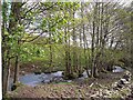
Penpont Burn
A tributary of the Scaur Water.
Image: © Oliver Dixon
Taken: 24 May 2009
0.19 miles
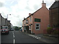
8
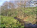
The Penpont Burn
Close to a minor road northwest of Penpont.
Image: © Walter Baxter
Taken: 24 Mar 2007
0.21 miles
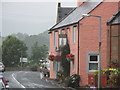
9

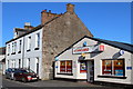
Volunteer Arms Hotel, Penpont
Old stone inn, with bright and modern stone paint, on the main road through Penpont.
Image: © Colin Smith
Taken: 31 Aug 2009
0.21 miles