IMAGES TAKEN NEAR TO
THORNHILL, DG3 4AU
Introduction
This page details the photographs taken nearby to DG3 4AU by members of the Geograph project.
The Geograph project started in 2005 with the aim of publishing, organising and preserving representative images for every square kilometre of Great Britain, Ireland and the Isle of Man.

There are currently over 7.5m images from over14,400 individuals and you can help contribute to the project by visiting https://www.geograph.org.uk
Image Map (Loading...)


Getting Data...Please wait
Leaflet Map data © OpenStreetMap
Images are licensed for reuse under creativecommons.org/licenses/by-sa/2.0
Notes
- Clicking on the map will re-center to the selected point.
- The higher the marker number, the further away the image location is from the centre of the postcode.
Image Listing (4 Images Found)
Images are licensed for reuse under creativecommons.org/licenses/by-sa/2.0
Image
Details
Distance
1

"The Ring"
Cottage between Penpont and Drumlanrig.
Image: © Oliver Dixon
Taken: 24 May 2009
0.01 miles
2
Near Honeyhole and Auchenbainzie
Not many large communities in this area of Nithsdale. The large wooded valley is Auchenknight Wood. An aerial view.
Image: © M J Richardson
Taken: 12 Dec 2014
0.14 miles
3
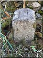
Old Milestone near Auchenbainzie
Milestone by the UC road, in parish of Penpont (Nithsdale District), near junctions for Auchenbainzie and Auchenknight, on verge in front of dry stone wall.
Inscription reads:-
17
(To Dumfries)
Pivot benchmark on top.
Surveyed
Milestone Society National ID: DG_DFSQUC17
Image: © Milestone Society
Taken: Unknown
0.19 miles
4
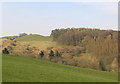
Pasture
A steeply sloping pasture field in the foreground with Townhead Wood beyond. Viewed from a minor road near Auchenbainzie.
Image: © Walter Baxter
Taken: 24 Mar 2007
0.22 miles