IMAGES TAKEN NEAR TO
THORNHILL, DG3 4AL
Introduction
This page details the photographs taken nearby to DG3 4AL by members of the Geograph project.
The Geograph project started in 2005 with the aim of publishing, organising and preserving representative images for every square kilometre of Great Britain, Ireland and the Isle of Man.

There are currently over 7.5m images from over14,400 individuals and you can help contribute to the project by visiting https://www.geograph.org.uk
Image Map (Loading...)


Getting Data...Please wait
Leaflet Map data © OpenStreetMap
Images are licensed for reuse under creativecommons.org/licenses/by-sa/2.0
Notes
- Clicking on the map will re-center to the selected point.
- The higher the marker number, the further away the image location is from the centre of the postcode.
Image Listing (10 Images Found)
Images are licensed for reuse under creativecommons.org/licenses/by-sa/2.0
Image
Details
Distance
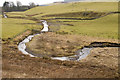
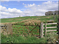
1
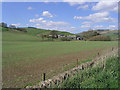
Burnsands
The Lowther Hills can be seen in the distance on the far side of Nithsdale.
Image: © Oliver Dixon
Taken: 22 Oct 2009
0.05 miles
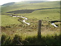
3
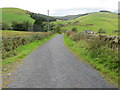
Road above Kirkcaldy and Burnsands
Looking north-westward.
Image: © Peter Wood
Taken: 13 Sep 2017
0.09 miles
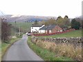
4
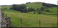
Towards Crairieknowe
Crairieknowe Farm hidden in the trees with Crairieknowe Dodd the hill beyond
Image: © Colin Kinnear
Taken: 13 Jul 2020
0.11 miles
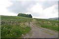
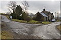
8
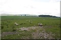
Rural landscape
Farmland to the south of Burnsands.
Image: © Walter Baxter
Taken: 26 Apr 2007
0.16 miles