IMAGES TAKEN NEAR TO
Speddoch, DUMFRIES, DG2 9UD
Introduction
This page details the photographs taken nearby to DG2 9UD by members of the Geograph project.
The Geograph project started in 2005 with the aim of publishing, organising and preserving representative images for every square kilometre of Great Britain, Ireland and the Isle of Man.

There are currently over 7.5m images from over14,400 individuals and you can help contribute to the project by visiting https://www.geograph.org.uk
Image Map
Images are licensed for reuse under creativecommons.org/licenses/by-sa/2.0
Notes
- Clicking on the map will re-center to the selected point.
- The higher the marker number, the further away the image location is from the centre of the postcode.
Image Listing (4 Images Found)
Images are licensed for reuse under creativecommons.org/licenses/by-sa/2.0
Image
Details
Distance
1
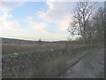
Marshy land near Slongaber
A well maintained dyke near Slongaber
Image: © David Robertson
Taken: 28 Dec 2008
0.07 miles
2
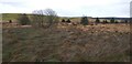
Rough ground at Slongaber
Taken from the roadside looking over an area of rough ground at Slongaber.
Image: © Colin Kinnear
Taken: 17 Jan 2021
0.13 miles
4
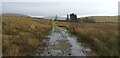
Track from Slongaber
The rough track from Slongaber out on to the open hills which is sheep farming country.
Image: © Colin Kinnear
Taken: 17 Jan 2021
0.21 miles