IMAGES TAKEN NEAR TO
Terregles, DUMFRIES, DG2 9SB
Introduction
This page details the photographs taken nearby to DG2 9SB by members of the Geograph project.
The Geograph project started in 2005 with the aim of publishing, organising and preserving representative images for every square kilometre of Great Britain, Ireland and the Isle of Man.

There are currently over 7.5m images from over14,400 individuals and you can help contribute to the project by visiting https://www.geograph.org.uk
Image Map
Images are licensed for reuse under creativecommons.org/licenses/by-sa/2.0
Notes
- Clicking on the map will re-center to the selected point.
- The higher the marker number, the further away the image location is from the centre of the postcode.
Image Listing (12 Images Found)
Images are licensed for reuse under creativecommons.org/licenses/by-sa/2.0
Image
Details
Distance
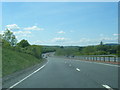
2
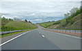
The A75 dual carriageway
Near Lochfoot, approaching Dumfries
Image: © Anthony O'Neil
Taken: 29 Apr 2017
0.11 miles
3
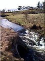
Cargen Water
Viewed from the cycle path
Image: © Darrin Antrobus
Taken: 27 Mar 2010
0.12 miles
4
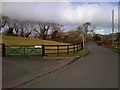
The road past Hillcrest
This is near the A75 west of Dumfries
Image: © Darrin Antrobus
Taken: 27 Mar 2010
0.14 miles
5
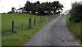
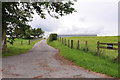
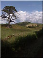
Track to Beltonhill
The rough track which leads up to Beltonhill Farm.
Image: © Colin Kinnear
Taken: 7 Aug 2008
0.15 miles
7
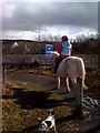
Horse on bike path
This is west of Dumfries, parallel to the A75 seen in the background
Image: © Darrin Antrobus
Taken: 27 Mar 2010
0.16 miles