IMAGES TAKEN NEAR TO
Sandypoint Drive, DUMFRIES, DG2 9RG
Introduction
This page details the photographs taken nearby to Sandypoint Drive, DG2 9RG by members of the Geograph project.
The Geograph project started in 2005 with the aim of publishing, organising and preserving representative images for every square kilometre of Great Britain, Ireland and the Isle of Man.

There are currently over 7.5m images from over14,400 individuals and you can help contribute to the project by visiting https://www.geograph.org.uk
Image Map
Images are licensed for reuse under creativecommons.org/licenses/by-sa/2.0
Notes
- Clicking on the map will re-center to the selected point.
- The higher the marker number, the further away the image location is from the centre of the postcode.
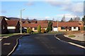
Image Listing (5 Images Found)
Images are licensed for reuse under creativecommons.org/licenses/by-sa/2.0
Image
Details
Distance
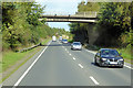
1
Leaving Dumfries
The Terregles Road leaves town for country.
Image: © Peter Mackenzie
Taken: 26 Aug 2017
0.14 miles
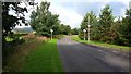
2
Yarrow Gardens
Yarrow Gardens, Dumfries.
Image: © Colin Kinnear
Taken: 4 Mar 2009
0.16 miles
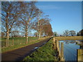
4
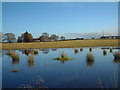
Flooded field
The result of relentless Scottish downpours
Image: © Hugh Close
Taken: 18 Nov 2012
0.21 miles