IMAGES TAKEN NEAR TO
Adamhill Road, DUMFRIES, DG2 9NF
Introduction
This page details the photographs taken nearby to Adamhill Road, DG2 9NF by members of the Geograph project.
The Geograph project started in 2005 with the aim of publishing, organising and preserving representative images for every square kilometre of Great Britain, Ireland and the Isle of Man.

There are currently over 7.5m images from over14,400 individuals and you can help contribute to the project by visiting https://www.geograph.org.uk
Image Map
Images are licensed for reuse under creativecommons.org/licenses/by-sa/2.0
Notes
- Clicking on the map will re-center to the selected point.
- The higher the marker number, the further away the image location is from the centre of the postcode.
Image Listing (11 Images Found)
Images are licensed for reuse under creativecommons.org/licenses/by-sa/2.0
Image
Details
Distance
3
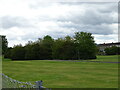
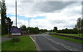
Green space and woodland near housing estate
Image: © JThomas
Taken: 22 May 2021
0.19 miles
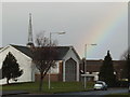
6

Kingdom Hall
Kingdom Hall of Jehova's Witnesses in Dumfries.
Image: © Colin Kinnear
Taken: 2 May 2020
0.22 miles
7
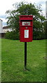
Elizabethan postbox on Newbridge Drive, Dumfries
Postbox No. DG2 208.
See Image] for context.
Image: © JThomas
Taken: 22 May 2021
0.23 miles
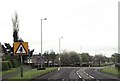
8
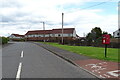
Newbridge Drive, Dumfries
Showing position of Postbox No. DG2 208.
See Image] for postbox.
Image: © JThomas
Taken: 22 May 2021
0.24 miles
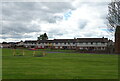
10
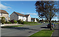
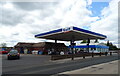
Lochside Road, Dumfries
Housing area on the NW side of the town.
Image: © Mary and Angus Hogg
Taken: 6 Oct 2018
0.24 miles