IMAGES TAKEN NEAR TO
Terregles Road, DUMFRIES, DG2 9HE
Introduction
This page details the photographs taken nearby to Terregles Road, DG2 9HE by members of the Geograph project.
The Geograph project started in 2005 with the aim of publishing, organising and preserving representative images for every square kilometre of Great Britain, Ireland and the Isle of Man.

There are currently over 7.5m images from over14,400 individuals and you can help contribute to the project by visiting https://www.geograph.org.uk
Image Map
Images are licensed for reuse under creativecommons.org/licenses/by-sa/2.0
Notes
- Clicking on the map will re-center to the selected point.
- The higher the marker number, the further away the image location is from the centre of the postcode.
Image Listing (12 Images Found)
Images are licensed for reuse under creativecommons.org/licenses/by-sa/2.0
Image
Details
Distance
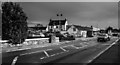

3
Roundabout
Lochfield stores and Border Cars
Image: © Hugh Close
Taken: 15 Feb 2014
0.02 miles
4
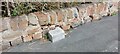
Old Boundary Marker Terregles Road, Maxwelltown
Municipal Boundary Marker on the north side of Terregles Road, Maxwelltown, 30 metres west of the junction with Hardthorn Road. PB is thought to refer to Maxwelltown Police Burgh, 1833 to 1929.
Milestone Society National ID: DF_MXT04pb
Image: © J Glew
Taken: 19 Apr 2022
0.03 miles

6
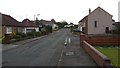
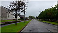
Hardthorn Avenue
An example of the housing in this quiet part of Dumfries.
Image: © Peter Mackenzie
Taken: 25 Aug 2017
0.15 miles
7
Lochfield Road, Dumfries
Opposite Palmerston Park.
Image: © Jonathan Billinger
Taken: 17 Aug 2013
0.18 miles
8
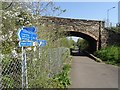
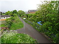
Under Terregles Road
The Paddy trackbed, once the railway to Stranraer and Portpatrick is now a popular walking and cycling route in Dumfies.
Image: © Richard Webb
Taken: 22 Apr 2019
0.18 miles
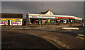
9

Queen of the South Arena
A redundant building (formerly a supermarket) has been fitted with two indoor pitches and other facilities to help the club finances.
Image: © Hugh Close
Taken: 15 Feb 2014
0.20 miles
10
Maxwelltown railway station (site), Dumfries & Galloway
Opened in 1859 by the Castle Douglas & Dumfries Railway, later part of the Glasgow & South Western Railway, this station closed to passengers in 1939 and completely in 1965. The railway line was known as 'The Port Road'.
View south west towards Lochanhead and Castle Douglas. The line from Dumfries to here was last used for freight in 1994. The platforms were still extant when this image was taken and the old station building on the right was a private residence.
Image: © Nigel Thompson
Taken: 7 May 2019
0.20 miles