IMAGES TAKEN NEAR TO
Caulstran Road, DUMFRIES, DG2 9FL
Introduction
This page details the photographs taken nearby to Caulstran Road, DG2 9FL by members of the Geograph project.
The Geograph project started in 2005 with the aim of publishing, organising and preserving representative images for every square kilometre of Great Britain, Ireland and the Isle of Man.

There are currently over 7.5m images from over14,400 individuals and you can help contribute to the project by visiting https://www.geograph.org.uk
Image Map
Images are licensed for reuse under creativecommons.org/licenses/by-sa/2.0
Notes
- Clicking on the map will re-center to the selected point.
- The higher the marker number, the further away the image location is from the centre of the postcode.
Image Listing (6 Images Found)
Images are licensed for reuse under creativecommons.org/licenses/by-sa/2.0
Image
Details
Distance
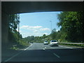
2
Bridge over the eastbound A75 (Dumfries Bypass)
Image: © David Dixon
Taken: 29 Sep 2017
0.19 miles
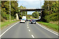
4
Bridge over the A75
This bridge carries Hardthorn Road over the A75.
Image: © Ann Cook
Taken: 15 Sep 2012
0.19 miles

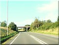
6
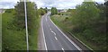
Empty Bypass
No traffic on the usually busy Dumfries bypass.
Image: © Colin Kinnear
Taken: 2 May 2020
0.23 miles