IMAGES TAKEN NEAR TO
Valleyfield Meadow, DUMFRIES, DG2 9AH
Introduction
This page details the photographs taken nearby to Valleyfield Meadow, DG2 9AH by members of the Geograph project.
The Geograph project started in 2005 with the aim of publishing, organising and preserving representative images for every square kilometre of Great Britain, Ireland and the Isle of Man.

There are currently over 7.5m images from over14,400 individuals and you can help contribute to the project by visiting https://www.geograph.org.uk
Image Map
Images are licensed for reuse under creativecommons.org/licenses/by-sa/2.0
Notes
- Clicking on the map will re-center to the selected point.
- The higher the marker number, the further away the image location is from the centre of the postcode.
Image Listing (8 Images Found)
Images are licensed for reuse under creativecommons.org/licenses/by-sa/2.0
Image
Details
Distance
3
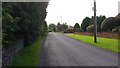
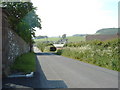
Terregles village
The road enters Terregles from the west.
Image: © Peter Mackenzie
Taken: 26 Aug 2017
0.12 miles
4

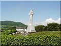
Terregles War Memorial
Square base surmounted by a tapering plinth, shaft and Celtic cross. Inscription in black lettering on two sides of the plinth. Steps lead up to memorial
Image: © Colin Kinnear
Taken: 6 May 2020
0.13 miles
6
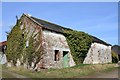
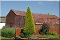
Terregles Outbuilding
An overgrown outbuilding which sits in the middle of new bungalows.
Image: © Colin Kinnear
Taken: 17 Mar 2009
0.20 miles
8
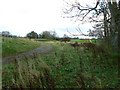
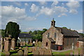
Track near Terregles
Looking east from near Terregles church.
Image: © James Allan
Taken: 9 Nov 2007
0.24 miles