IMAGES TAKEN NEAR TO
Crocketford, DUMFRIES, DG2 8RW
Introduction
This page details the photographs taken nearby to DG2 8RW by members of the Geograph project.
The Geograph project started in 2005 with the aim of publishing, organising and preserving representative images for every square kilometre of Great Britain, Ireland and the Isle of Man.

There are currently over 7.5m images from over14,400 individuals and you can help contribute to the project by visiting https://www.geograph.org.uk
Image Map
Images are licensed for reuse under creativecommons.org/licenses/by-sa/2.0
Notes
- Clicking on the map will re-center to the selected point.
- The higher the marker number, the further away the image location is from the centre of the postcode.
Image Listing (4 Images Found)
Images are licensed for reuse under creativecommons.org/licenses/by-sa/2.0
Image
Details
Distance
1
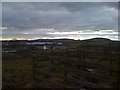
Barfil Farm and Milton Loch
Overlooking the steading at Barfil Farm, with Milton Loch in the distance
Image: © Darrin Antrobus
Taken: 27 Jan 2011
0.03 miles
2
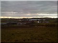
Baril Farm
Barfil, with Milton Loch in the distance
Image: © Darrin Antrobus
Taken: 27 Jan 2011
0.05 miles
3
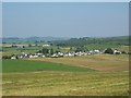
Crocketford Village
This photo was taken not far from the top of Crocketford Hill.
Image: © David Proudlock
Taken: 10 Jul 2006
0.11 miles
4
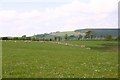
Ewes & lambs on Longshott looking north above A75
The woodland planting just behind the sheep was planted in Longshott field 15 years ago. The forestry plantation beyond the hedgeline is on the other side of the valley and sits behind Larglanlee. The village of Crocketford is off to the north west.
Image: © M Gordon
Taken: 10 May 2008
0.24 miles