IMAGES TAKEN NEAR TO
Castle Douglas Road, DUMFRIES, DG2 8RU
Introduction
This page details the photographs taken nearby to Castle Douglas Road, DG2 8RU by members of the Geograph project.
The Geograph project started in 2005 with the aim of publishing, organising and preserving representative images for every square kilometre of Great Britain, Ireland and the Isle of Man.

There are currently over 7.5m images from over14,400 individuals and you can help contribute to the project by visiting https://www.geograph.org.uk
Image Map
Images are licensed for reuse under creativecommons.org/licenses/by-sa/2.0
Notes
- Clicking on the map will re-center to the selected point.
- The higher the marker number, the further away the image location is from the centre of the postcode.
Image Listing (20 Images Found)
Images are licensed for reuse under creativecommons.org/licenses/by-sa/2.0
Image
Details
Distance
1
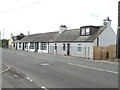
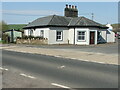
A row of cottages on the A75
At the western end of Crocketford or Ninemile Bar. Known simply as Crocketford on the GB1900.org map. It is approximately equidistant between Castle Douglas and Dumfries.
Image: © M J Richardson
Taken: 26 Sep 2022
0.01 miles
2
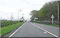
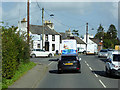
Entering Crocketford
... via the A75
Image: © Anthony O'Neil
Taken: 29 Apr 2017
0.01 miles
3
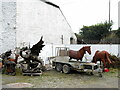
Horses and a Dragon at Brass Tacks
Some fine life-like sculptures at Brass Tacks at Home, a supplier of upholstery services, garden ornaments, bronzes etc., etc.
Image: © M J Richardson
Taken: 26 Sep 2022
0.02 miles
4
Bronzes at Brass Tacks, Crocketford
A range of life-like sculptures at Brass Tacks at Home, a supplier of upholstery services, garden ornaments, bronzes etc., etc.
Image: © M J Richardson
Taken: 26 Sep 2022
0.02 miles
5
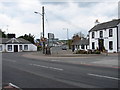
Crocketford or Ninemile Bar
A quiet moment on the busy A75 that cuts through Crocketford. Opposite is the A712 for New Galloway, on the junction is Ninemilebar Toll-house (C18), to the right is the Galloway Arms with the local store/post office just beyond.
Crocketford is strictly a hamlet as it has no church, despite being founded in 1787 by a religious sect, known as the Buchanites.
Image: © Chris Newman
Taken: 21 May 2008
0.03 miles
6
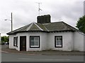
Old tollhouse
A view across the A75 of the tollhouse at the A75/A712 junction in Crocketford/Nine Mile Bar. An interesting feature is the central 4 stack chimneys. The windows are 4 pane rectangular sash.
Image: © Chris Minto
Taken: 21 Apr 2023
0.03 miles
7
Old tollhouse
A view of Crocketford tollhouse across the A715. The original building was designed by A Halliday of Dumfries in 1834 with additions in later years.
Image: © Chris Minto
Taken: 21 Apr 2023
0.03 miles
8
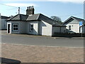
Junction at Crocketford
The junction of the A712 and the A75 outside the Galloway Arms at Crocketford.
Image: © David Dixon
Taken: 29 Sep 2017
0.04 miles
9
Former Toll House by Ninemile Bar or Crocketford
Crocketford Toll House by the A75, in parish of Crocketford (Dumfries and Galloway District), Toll House, Maiden Row.
HES Scotland Category 'B' listed.
Reference: LB9669 http://portal.historicenvironment.scot/designation/LB9669
Surveyed
Milestone Society National ID: DG.CRO
Image: © Milestone Society
Taken: Unknown
0.04 miles
10
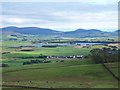
Crocketford and Milton Loch
Part of Crocketford village with Milton Loch in the background.
Image: © David Proudlock
Taken: 2 Sep 2008
0.06 miles