IMAGES TAKEN NEAR TO
Crocketford, DUMFRIES, DG2 8RG
Introduction
This page details the photographs taken nearby to DG2 8RG by members of the Geograph project.
The Geograph project started in 2005 with the aim of publishing, organising and preserving representative images for every square kilometre of Great Britain, Ireland and the Isle of Man.

There are currently over 7.5m images from over14,400 individuals and you can help contribute to the project by visiting https://www.geograph.org.uk
Image Map
Images are licensed for reuse under creativecommons.org/licenses/by-sa/2.0
Notes
- Clicking on the map will re-center to the selected point.
- The higher the marker number, the further away the image location is from the centre of the postcode.
Image Listing (3 Images Found)
Images are licensed for reuse under creativecommons.org/licenses/by-sa/2.0
Image
Details
Distance
1
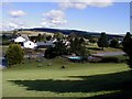
Park of Brandedleys main buildings
Park of Brandedleys Crocketford looking over the main buildings, outdoor pool, tennis courts, car park and camping area off to the right.
Image: © Steve Houldsworth
Taken: 20 Aug 2005
0.16 miles
2
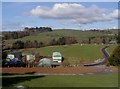
Park of Brandedleys
The camping ground and some of the static caravans near the pond at the park of Brandedleys Crocketford.
Image: © Steve Houldsworth
Taken: 20 Aug 2005
0.17 miles
3
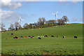
Farmland at Auchengibbert
Shenrick Hill is in the background.
Image: © Walter Baxter
Taken: 20 Apr 2018
0.23 miles