IMAGES TAKEN NEAR TO
Crocketford, DUMFRIES, DG2 8QT
Introduction
This page details the photographs taken nearby to DG2 8QT by members of the Geograph project.
The Geograph project started in 2005 with the aim of publishing, organising and preserving representative images for every square kilometre of Great Britain, Ireland and the Isle of Man.

There are currently over 7.5m images from over14,400 individuals and you can help contribute to the project by visiting https://www.geograph.org.uk
Image Map
Images are licensed for reuse under creativecommons.org/licenses/by-sa/2.0
Notes
- Clicking on the map will re-center to the selected point.
- The higher the marker number, the further away the image location is from the centre of the postcode.
Image Listing (9 Images Found)
Images are licensed for reuse under creativecommons.org/licenses/by-sa/2.0
Image
Details
Distance
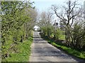
1
Old Military Road, Milton
Entering Milton from the east.
Image: © Richard Webb
Taken: 22 Apr 2019
0.02 miles
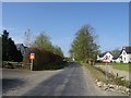
2
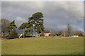
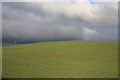
Newark
Looking across good grazing towards Newark.
Image: © Colin Kinnear
Taken: 20 Nov 2010
0.07 miles
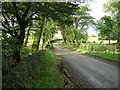
3
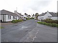
Village street, Milton
An isolated hamlet near Crocketford. The street lies on the line of the old Military Road and carries National Cycle Network route 7.
Image: © Oliver Dixon
Taken: 23 May 2009
0.09 miles
4
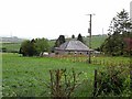
Mackenzie's Cottage
Cottage near Milton. Named on the Pathfinder map as "Hillview".
Image: © Oliver Dixon
Taken: 23 May 2009
0.14 miles
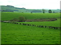
6
Good grazing near Milton
Good grazing near to the hamlet of Milton.
Image: © Colin Kinnear
Taken: 20 Nov 2010
0.15 miles