IMAGES TAKEN NEAR TO
Crocketford, DUMFRIES, DG2 8QH
Introduction
This page details the photographs taken nearby to DG2 8QH by members of the Geograph project.
The Geograph project started in 2005 with the aim of publishing, organising and preserving representative images for every square kilometre of Great Britain, Ireland and the Isle of Man.

There are currently over 7.5m images from over14,400 individuals and you can help contribute to the project by visiting https://www.geograph.org.uk
Image Map
Images are licensed for reuse under creativecommons.org/licenses/by-sa/2.0
Notes
- Clicking on the map will re-center to the selected point.
- The higher the marker number, the further away the image location is from the centre of the postcode.
Image Listing (7 Images Found)
Images are licensed for reuse under creativecommons.org/licenses/by-sa/2.0
Image
Details
Distance
5
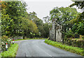
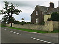
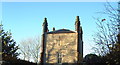
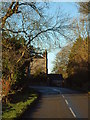
Curious walling close to Brooklands
The high wall to the right of the road (A712), west of Crocketford is unusual. It has three sections, all crenellated with the centre one being taller than the others. The part nearest to the camera has a small, now roofless building incorporated into the rear. The structure stands opposite to the entrance to the property at Brooklands.
A possible folly?
Image: © Trevor Littlewood
Taken: 16 Oct 2021
0.11 miles
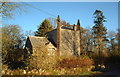
7
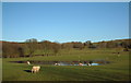
Foreground sheep with Brooklands in the distance
Image: © Hugh Close
Taken: 16 Jan 2012
0.21 miles