IMAGES TAKEN NEAR TO
DUMFRIES, DG2 8PR
Introduction
This page details the photographs taken nearby to DG2 8PR by members of the Geograph project.
The Geograph project started in 2005 with the aim of publishing, organising and preserving representative images for every square kilometre of Great Britain, Ireland and the Isle of Man.

There are currently over 7.5m images from over14,400 individuals and you can help contribute to the project by visiting https://www.geograph.org.uk
Image Map
Images are licensed for reuse under creativecommons.org/licenses/by-sa/2.0
Notes
- Clicking on the map will re-center to the selected point.
- The higher the marker number, the further away the image location is from the centre of the postcode.
Image Listing (16 Images Found)
Images are licensed for reuse under creativecommons.org/licenses/by-sa/2.0
Image
Details
Distance
1
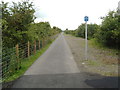
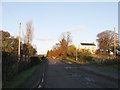
Maxwelltown Cycle Path, route no. 7 of the National Cycle Path Network
It follows the route of a disused railway at this point.
Image: © Darrin Antrobus
Taken: 6 Jul 2007
0.20 miles
3
Cargenbridge
Looking towards Garroch and the A75.
Image: © Andy Farrington
Taken: 21 Apr 2014
0.20 miles
4
Garroch
Link road between the A75 and the A711 leads in this direction to Dumfries and Dalbeattie at the Cargenbridge Roundabout.
Image: © Andy Farrington
Taken: 21 Apr 2014
0.21 miles
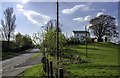
6
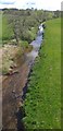
Cargen Water
Looking down on the Cargen Water from the cycle track.
Image: © Colin Kinnear
Taken: 27 Apr 2020
0.22 miles
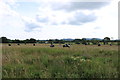
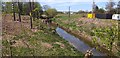
7
Cargen Water
seen from an old railway bridge, now a cycle path.
Image: © Darrin Antrobus
Taken: 6 Jul 2007
0.22 miles
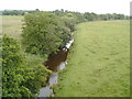
8
Cargen Water
Cargen Water, a small stream which runs past Cargenbridge.
Image: © Colin Kinnear
Taken: 24 Apr 2020
0.22 miles
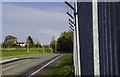
10
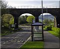
Garroch Viaduct
No longer in use to carry the rail line it still spans the road to Garroch and the A75.
Image: © Andy Farrington
Taken: 21 Apr 2014
0.23 miles