IMAGES TAKEN NEAR TO
Lochfoot, DUMFRIES, DG2 8NX
Introduction
This page details the photographs taken nearby to DG2 8NX by members of the Geograph project.
The Geograph project started in 2005 with the aim of publishing, organising and preserving representative images for every square kilometre of Great Britain, Ireland and the Isle of Man.

There are currently over 7.5m images from over14,400 individuals and you can help contribute to the project by visiting https://www.geograph.org.uk
Image Map
Images are licensed for reuse under creativecommons.org/licenses/by-sa/2.0
Notes
- Clicking on the map will re-center to the selected point.
- The higher the marker number, the further away the image location is from the centre of the postcode.
Image Listing (9 Images Found)
Images are licensed for reuse under creativecommons.org/licenses/by-sa/2.0
Image
Details
Distance
1
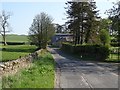
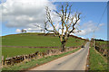
Old Military Road, Gateside
The course of Caulfeild's road to Portpatrick.
Image: © Richard Webb
Taken: 22 Apr 2019
0.06 miles
4
Pasture near Barbackle
With a wetland hollow.
Image: © Richard Webb
Taken: 22 Apr 2019
0.15 miles
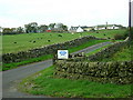
6
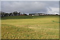
Barnbackle Farm
Looking across good grazing land to the farm of Barnbackle.
Image: © Colin Kinnear
Taken: 20 Nov 2010
0.20 miles
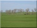
7
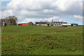
Barnbackle Farm
The farm was viewed from the Old Military Road.
Image: © Walter Baxter
Taken: 20 Apr 2018
0.21 miles
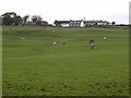
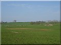
9
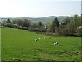
Three Crofts
The ground is higher here than further west and more sheep can be seen as opposed to Friesian cows.
Image: © Richard Webb
Taken: 22 Apr 2019
0.25 miles