IMAGES TAKEN NEAR TO
Troqueer, DUMFRIES, DG2 8NB
Introduction
This page details the photographs taken nearby to DG2 8NB by members of the Geograph project.
The Geograph project started in 2005 with the aim of publishing, organising and preserving representative images for every square kilometre of Great Britain, Ireland and the Isle of Man.

There are currently over 7.5m images from over14,400 individuals and you can help contribute to the project by visiting https://www.geograph.org.uk
Image Map
Images are licensed for reuse under creativecommons.org/licenses/by-sa/2.0
Notes
- Clicking on the map will re-center to the selected point.
- The higher the marker number, the further away the image location is from the centre of the postcode.
Image Listing (9 Images Found)
Images are licensed for reuse under creativecommons.org/licenses/by-sa/2.0
Image
Details
Distance
1
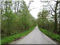
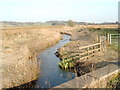
Moss Road
A straight road crosses a marshy area below Mabie Forest.
Image: © Richard Webb
Taken: 23 May 2013
0.11 miles
2
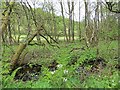
Wetland, Moss Road
Marshy ground beneath Mabie Forest.
Image: © Richard Webb
Taken: 23 May 2013
0.12 miles
3
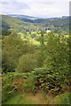
Mabie Forest
Taken on the Red Route of the 7 Stanes Mountain Bike Trails whilst walking up the Scorpion.
In the distance is the Goldielea viaduct built by the Castle-Douglas and Dumfries Railway Company (Image).
Image: © Mick Garratt
Taken: 17 Aug 2010
0.13 miles
4
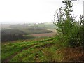
Path, Moss-side Plantation
Used by the red mountainbike route, the track traverses a very steep slope.
Image: © Richard Webb
Taken: 23 May 2013
0.13 miles
6
The Scorpion
Climb on the Mabie red route. I thought I had it licked, but scorpions have a sting in their tail. The last bit up to the road at the top is very steep.
Image: © Richard Webb
Taken: 23 May 2013
0.15 miles
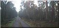
7
Path, Mabie Forest
The Ordnance Survey show a ride here, the block to the left has been harvested. Moss-side Plantation is very steep and there are good views from its paths.
Image: © Richard Webb
Taken: 23 May 2013
0.16 miles
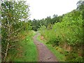
8
Into the trees
Track leading to Deepwater.
Image: © Colin Kinnear
Taken: 22 Dec 2020
0.22 miles
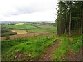
9
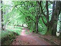
Old boundary, Larch Hill
A line of mature beeches marks the former boundary between Moss-side Plantation and what was once open hill. The path is used by the red mountainbike route.
Image: © Richard Webb
Taken: 23 May 2013
0.23 miles