IMAGES TAKEN NEAR TO
DUMFRIES, DG2 8NA
Introduction
This page details the photographs taken nearby to DG2 8NA by members of the Geograph project.
The Geograph project started in 2005 with the aim of publishing, organising and preserving representative images for every square kilometre of Great Britain, Ireland and the Isle of Man.

There are currently over 7.5m images from over14,400 individuals and you can help contribute to the project by visiting https://www.geograph.org.uk
Image Map
Images are licensed for reuse under creativecommons.org/licenses/by-sa/2.0
Notes
- Clicking on the map will re-center to the selected point.
- The higher the marker number, the further away the image location is from the centre of the postcode.
Image Listing (5 Images Found)
Images are licensed for reuse under creativecommons.org/licenses/by-sa/2.0
Image
Details
Distance
1
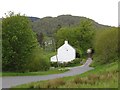
Moss Cottage
On an old road alignment. Mabie Forest is in the background.
Image: © Richard Webb
Taken: 23 May 2013
0.03 miles
2
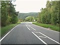
Turning to Mabie and New Abbey on the A711
Image: © Ann Cook
Taken: 18 Sep 2010
0.05 miles
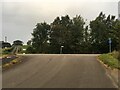
4
Moss Road
Single track road, viewed near Dalbeattie Rd end heading toward New Abbey Road
Image: © Darrin Antrobus
Taken: 2 Apr 2007
0.12 miles
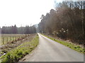
5
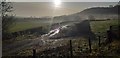
Early morning sun
Early morning sun near Moss Cottage.
Image: © Colin Kinnear
Taken: 27 Nov 2019
0.15 miles