IMAGES TAKEN NEAR TO
Troqueer, DUMFRIES, DG2 8LZ
Introduction
This page details the photographs taken nearby to DG2 8LZ by members of the Geograph project.
The Geograph project started in 2005 with the aim of publishing, organising and preserving representative images for every square kilometre of Great Britain, Ireland and the Isle of Man.

There are currently over 7.5m images from over14,400 individuals and you can help contribute to the project by visiting https://www.geograph.org.uk
Image Map
Images are licensed for reuse under creativecommons.org/licenses/by-sa/2.0
Notes
- Clicking on the map will re-center to the selected point.
- The higher the marker number, the further away the image location is from the centre of the postcode.
Image Listing (7 Images Found)
Images are licensed for reuse under creativecommons.org/licenses/by-sa/2.0
Image
Details
Distance
1
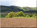
Cultivated ground, Carruchan
View across The Moss towards Mabie Forest.
Image: © Richard Webb
Taken: 23 May 2013
0.06 miles
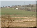
4
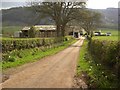
Carruchan Farm
The farm track down to Carruchan Farm.
Image: © Colin Kinnear
Taken: 29 Apr 2008
0.17 miles
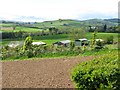
5
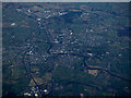
Dumfries from the air
Looking over the town from the south west.
Image: © Thomas Nugent
Taken: 11 Feb 2019
0.19 miles
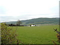
7
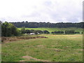
Fields at Cargenholm
At the northern end of the wooded ridge beyond there is apparently a Covenanters' Cave.
Image: © M J Richardson
Taken: 21 Sep 2007
0.24 miles