IMAGES TAKEN NEAR TO
Dalbeattie Road, DUMFRIES, DG2 8LW
Introduction
This page details the photographs taken nearby to Dalbeattie Road, DG2 8LW by members of the Geograph project.
The Geograph project started in 2005 with the aim of publishing, organising and preserving representative images for every square kilometre of Great Britain, Ireland and the Isle of Man.

There are currently over 7.5m images from over14,400 individuals and you can help contribute to the project by visiting https://www.geograph.org.uk
Image Map
Images are licensed for reuse under creativecommons.org/licenses/by-sa/2.0
Notes
- Clicking on the map will re-center to the selected point.
- The higher the marker number, the further away the image location is from the centre of the postcode.
Image Listing (10 Images Found)
Images are licensed for reuse under creativecommons.org/licenses/by-sa/2.0
Image
Details
Distance
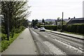
1
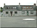
Cottages on the A711
There is a mini-roundabout in front of the cottages. This roundabout is at the junction of the A711 and the minor road that leads, through Garroch, to the A75.
Image: © Ann Cook
Taken: 18 Sep 2010
0.03 miles
3
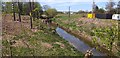
Cargen Water
Cargen Water, a small stream which runs past Cargenbridge.
Image: © Colin Kinnear
Taken: 24 Apr 2020
0.08 miles
4
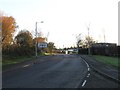
Cargenbridge Roundabout
Looking towards the roundabout and junction with the A711.
Image: © Andy Farrington
Taken: 21 Apr 2014
0.09 miles
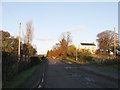
6
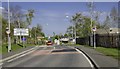
Cargenbridge
Looking towards Garroch and the A75.
Image: © Andy Farrington
Taken: 21 Apr 2014
0.14 miles
7
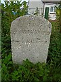
Old milestone
On the A711, south west of Dumfries near Cargenbridge on the verge in front of a house boundary. The '1 mile to Dumfries Bridge' is to the 'new' Buccleuch Street bridge built in the 1790s. There is a benchmark pin in the top edge. May be a stone put up by the Dalbeattie Trust.
Image: © Chris Minto
Taken: 26 Aug 2019
0.19 miles
8
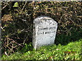
Old Milestone by the A711, Troqueer parish
Stone post by the A711, in parish of Troqueer (Nithsdale District), South of A780 junction opposite lamppost 102. By hedge on footpath in front of Robingsmal.
Inscription reads:-
DUMFRIES BRIDGE
--->1 MILE--->
Surveyed
Milestone Society National ID: DG_DFDB01
Image: © Milestone Society
Taken: Unknown
0.19 miles
9
A711 at Curriestanes
Looking south west towards Cargenbridge.
Image: © Andy Farrington
Taken: 21 Apr 2014
0.20 miles
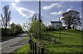
10
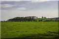
Curriestanes
View across grazing field towards Priestlands.
Image: © Andy Farrington
Taken: 21 Apr 2014
0.23 miles