IMAGES TAKEN NEAR TO
Kirkgunzeon, DUMFRIES, DG2 8JU
Introduction
This page details the photographs taken nearby to DG2 8JU by members of the Geograph project.
The Geograph project started in 2005 with the aim of publishing, organising and preserving representative images for every square kilometre of Great Britain, Ireland and the Isle of Man.

There are currently over 7.5m images from over14,400 individuals and you can help contribute to the project by visiting https://www.geograph.org.uk
Image Map
Images are licensed for reuse under creativecommons.org/licenses/by-sa/2.0
Notes
- Clicking on the map will re-center to the selected point.
- The higher the marker number, the further away the image location is from the centre of the postcode.
Image Listing (6 Images Found)
Images are licensed for reuse under creativecommons.org/licenses/by-sa/2.0
Image
Details
Distance
3
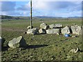
Boulders, Bentfoot
Granite boulders piled up after being cleared from the fields.
Image: © Richard Webb
Taken: 5 Mar 2006
0.09 miles
4
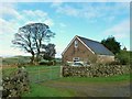
A building next door to Bents
Is this a new build or a conversion from an old one? Work has been done on the building recently. The chimney of Bents can be seen, next door.
Image: © Ann Cook
Taken: 5 Oct 2012
0.13 miles