IMAGES TAKEN NEAR TO
Lochanhead, DUMFRIES, DG2 8JD
Introduction
This page details the photographs taken nearby to DG2 8JD by members of the Geograph project.
The Geograph project started in 2005 with the aim of publishing, organising and preserving representative images for every square kilometre of Great Britain, Ireland and the Isle of Man.

There are currently over 7.5m images from over14,400 individuals and you can help contribute to the project by visiting https://www.geograph.org.uk
Image Map
Images are licensed for reuse under creativecommons.org/licenses/by-sa/2.0
Notes
- Clicking on the map will re-center to the selected point.
- The higher the marker number, the further away the image location is from the centre of the postcode.
Image Listing (8 Images Found)
Images are licensed for reuse under creativecommons.org/licenses/by-sa/2.0
Image
Details
Distance
1
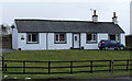
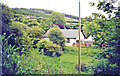
'Marshside'
Marshside is a bungalow on the south-east side of the A711 at Lochanhead, between Dumfries and Dalbeattie.
Image: © Trevor Littlewood
Taken: 12 Feb 2011
0.02 miles
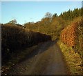
2
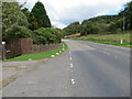
Road (A711) at Lochanhead
Looking north-eastward.
Image: © Peter Wood
Taken: 24 Sep 2014
0.02 miles
3
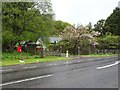
Lochanhead railway station (site), Dumfries & Galloway
Opened in 1859 by the Castle Douglas & Dumfries Railway, later part of the Glasgow & South Western Railway, this station closed to passengers in 1939 and completely in 1965. The railway line was known as 'The Port Road'.
View north at the forecourt, now a private residence. The former track-bed is behind the building.
Image: © Nigel Thompson
Taken: 7 May 2019
0.04 miles
4
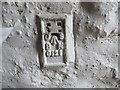
Ordnance Survey Flush Bracket G121
This can be found on the former Station Masters house - now a private dwelling - at Lochanead.
For more detail see : http://www.bench-marks.org.uk/bm16695
Image: © Peter Wood
Taken: 24 Sep 2014
0.04 miles
5
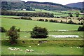
Lochanhead: site/remains of station, 2000
View southward. The former 'Ports Line', ex-G&SWR section, Dumfries (to left) - Castle Douglas), of the (Carlisle) - Dumfries - Stranraer main line, passed through here until closed 14/6/65. Lochanhead station was closed to passengers 25/9/39, to goods 5/47.
Image: © Ben Brooksbank
Taken: 23 Jun 2000
0.05 miles
6
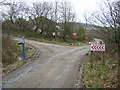
Sunlit Track
The track which leads to Mabie Forest.
Image: © Colin Kinnear
Taken: 12 Jan 2009
0.12 miles
8
Cycle Track in Mabie Forest
Part of Mabie Forest blue cycle trail
Image: © Iain Thompson
Taken: 26 Feb 2006
0.14 miles