IMAGES TAKEN NEAR TO
New Abbey, DUMFRIES, DG2 8HN
Introduction
This page details the photographs taken nearby to DG2 8HN by members of the Geograph project.
The Geograph project started in 2005 with the aim of publishing, organising and preserving representative images for every square kilometre of Great Britain, Ireland and the Isle of Man.

There are currently over 7.5m images from over14,400 individuals and you can help contribute to the project by visiting https://www.geograph.org.uk
Image Map
Images are licensed for reuse under creativecommons.org/licenses/by-sa/2.0
Notes
- Clicking on the map will re-center to the selected point.
- The higher the marker number, the further away the image location is from the centre of the postcode.
Image Listing (3 Images Found)
Images are licensed for reuse under creativecommons.org/licenses/by-sa/2.0
Image
Details
Distance
1
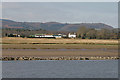
Maxwellbank Farm
Viewed across the River Nith from Glencaple.
Image: © Walter Baxter
Taken: 25 Mar 2011
0.01 miles
2
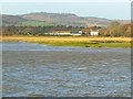
Maxwellbank farm
Seen from the opposite bank of the river Nith, in Glencaple.
Image: © James Allan
Taken: 8 Nov 2007
0.04 miles
3
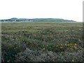
Kirconnell Merse
Marshy wetlands near the Nith. The village in the background is Glencaple, on the other bank of the river.
Image: © James Allan
Taken: 9 Nov 2007
0.25 miles