IMAGES TAKEN NEAR TO
New Abbey, DUMFRIES, DG2 8HL
Introduction
This page details the photographs taken nearby to DG2 8HL by members of the Geograph project.
The Geograph project started in 2005 with the aim of publishing, organising and preserving representative images for every square kilometre of Great Britain, Ireland and the Isle of Man.

There are currently over 7.5m images from over14,400 individuals and you can help contribute to the project by visiting https://www.geograph.org.uk
Image Map
Images are licensed for reuse under creativecommons.org/licenses/by-sa/2.0
Notes
- Clicking on the map will re-center to the selected point.
- The higher the marker number, the further away the image location is from the centre of the postcode.
Image Listing (4 Images Found)
Images are licensed for reuse under creativecommons.org/licenses/by-sa/2.0
Image
Details
Distance
1
The Park road
Taken from the junction, this is the road which leads to The Park.
Image: © Colin Kinnear
Taken: 12 Mar 2010
0.07 miles
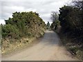
2

Gorse lined road
Leading to the Park and Brioch Park
Image: © James Allan
Taken: 9 Nov 2007
0.09 miles
3
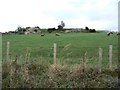
Sheep by the rocks
Most of the land in this vicinity is low-lying and marshy but there are occasional rocky outcrops such as this one here, south of Kirconnell Estate.
Image: © James Allan
Taken: 9 Nov 2007
0.12 miles
4
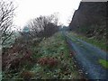
Track with passing places
On the way to Airds Point.
Image: © Gordon Brown
Taken: 1 Jan 2009
0.19 miles