IMAGES TAKEN NEAR TO
New Abbey, DUMFRIES, DG2 8HH
Introduction
This page details the photographs taken nearby to DG2 8HH by members of the Geograph project.
The Geograph project started in 2005 with the aim of publishing, organising and preserving representative images for every square kilometre of Great Britain, Ireland and the Isle of Man.

There are currently over 7.5m images from over14,400 individuals and you can help contribute to the project by visiting https://www.geograph.org.uk
Image Map
Images are licensed for reuse under creativecommons.org/licenses/by-sa/2.0
Notes
- Clicking on the map will re-center to the selected point.
- The higher the marker number, the further away the image location is from the centre of the postcode.
Image Listing (20 Images Found)
Images are licensed for reuse under creativecommons.org/licenses/by-sa/2.0
Image
Details
Distance
2
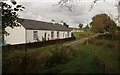
Lintmill
Just northeast of the ford across the New Abbey Pow Burn.
Image: © Richard Sutcliffe
Taken: 20 Oct 2016
0.13 miles
3
Lintmill
The road leads down to a ford across the New Abbey Pow burn just past the house. The wire mesh enclosures behind the vehicle hold chickens.
Image: © Richard Sutcliffe
Taken: 20 Oct 2016
0.13 miles
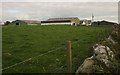
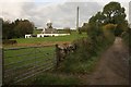
5
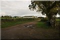
Maryfield Farm
The road runs past Maryfield to Carse, nearly a kilometre further on.
Image: © Richard Sutcliffe
Taken: 20 Oct 2016
0.13 miles
6
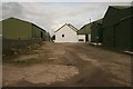
Maryfield Farm
Modern sheds surrounding a much older building in the centre.
Image: © Richard Sutcliffe
Taken: 20 Oct 2016
0.15 miles
8
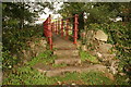
Footbridge over the New Abbey Pow burn
Image: © Richard Sutcliffe
Taken: 20 Oct 2016
0.15 miles
9
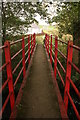
Footbridge over the New Abbey Pow Burn
Image: © Richard Sutcliffe
Taken: 20 Oct 2016
0.15 miles
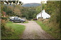
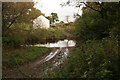
10
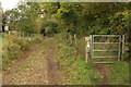
Track down to the ford
The wheel ruts lead down to a ford across the New Abbey Pow Burn (just visible behind the far gate). Luckily the footpath takes a different route, and there is a footbridge [http://www.geograph.org.uk/photo/5163510] just downstream of the ford.
Image: © Richard Sutcliffe
Taken: 20 Oct 2016
0.15 miles