IMAGES TAKEN NEAR TO
Locharthur Place, DUMFRIES, DG2 8FA
Introduction
This page details the photographs taken nearby to Locharthur Place, DG2 8FA by members of the Geograph project.
The Geograph project started in 2005 with the aim of publishing, organising and preserving representative images for every square kilometre of Great Britain, Ireland and the Isle of Man.

There are currently over 7.5m images from over14,400 individuals and you can help contribute to the project by visiting https://www.geograph.org.uk
Image Map
Images are licensed for reuse under creativecommons.org/licenses/by-sa/2.0
Notes
- Clicking on the map will re-center to the selected point.
- The higher the marker number, the further away the image location is from the centre of the postcode.
Image Listing (4 Images Found)
Images are licensed for reuse under creativecommons.org/licenses/by-sa/2.0
Image
Details
Distance
2
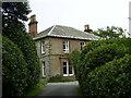
Locharthur House, Beeswing
Looking east along the driveway towards Locharthur house near Beeswing. Loch Arthur is just over the hill behind the house.
Image: © David Radcliffe
Taken: 18 Aug 2004
0.15 miles
4
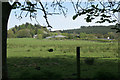
Farm buildings, Locharthur
Viewed from beside the Loch Arthur Farm Shop and Cafe.
Image: © Richard Sutcliffe
Taken: 12 May 2018
0.20 miles