IMAGES TAKEN NEAR TO
Mavis Grove, DUMFRIES, DG2 8EP
Introduction
This page details the photographs taken nearby to Mavis Grove, DG2 8EP by members of the Geograph project.
The Geograph project started in 2005 with the aim of publishing, organising and preserving representative images for every square kilometre of Great Britain, Ireland and the Isle of Man.

There are currently over 7.5m images from over14,400 individuals and you can help contribute to the project by visiting https://www.geograph.org.uk
Image Map
Images are licensed for reuse under creativecommons.org/licenses/by-sa/2.0
Notes
- Clicking on the map will re-center to the selected point.
- The higher the marker number, the further away the image location is from the centre of the postcode.
Image Listing (3 Images Found)
Images are licensed for reuse under creativecommons.org/licenses/by-sa/2.0
Image
Details
Distance
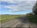
1
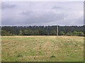
Laghall
Looking across a stubble field from the A710 towards the River Nith in the dip beyond.
Image: © M J Richardson
Taken: 21 Sep 2007
0.13 miles
2
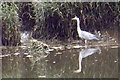
Heron at Kingholm
A grey heron waits for supper on the muddy margin of the tidal Nith.
Image: © Tiger
Taken: 8 Jul 2019
0.16 miles