IMAGES TAKEN NEAR TO
New Abbey, DUMFRIES, DG2 8EA
Introduction
This page details the photographs taken nearby to DG2 8EA by members of the Geograph project.
The Geograph project started in 2005 with the aim of publishing, organising and preserving representative images for every square kilometre of Great Britain, Ireland and the Isle of Man.

There are currently over 7.5m images from over14,400 individuals and you can help contribute to the project by visiting https://www.geograph.org.uk
Image Map
Images are licensed for reuse under creativecommons.org/licenses/by-sa/2.0
Notes
- Clicking on the map will re-center to the selected point.
- The higher the marker number, the further away the image location is from the centre of the postcode.
Image Listing (18 Images Found)
Images are licensed for reuse under creativecommons.org/licenses/by-sa/2.0
Image
Details
Distance
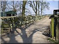
3
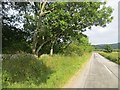
Auchengray Farm track
Start of track which leads to Auchengray Farm.
Image: © Colin Kinnear
Taken: 11 Dec 2010
0.07 miles
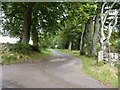

6
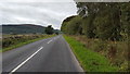
The road to Beeswing
The road from New Abbey heading towards Beeswing.
Image: © Peter Mackenzie
Taken: 5 Sep 2018
0.13 miles
9
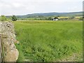
Field near Auchengray
Winter fodder being grown in the rugged area southwest of Dumfries.
Image: © Richard Webb
Taken: 21 Jul 2013
0.16 miles
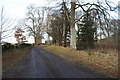
10

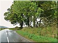
The road to Beeswing
This view is taken from the entrance to Riddlebank.
Image: © Ann Cook
Taken: 3 Oct 2012
0.17 miles