IMAGES TAKEN NEAR TO
New Abbey, DUMFRIES, DG2 8DZ
Introduction
This page details the photographs taken nearby to DG2 8DZ by members of the Geograph project.
The Geograph project started in 2005 with the aim of publishing, organising and preserving representative images for every square kilometre of Great Britain, Ireland and the Isle of Man.

There are currently over 7.5m images from over14,400 individuals and you can help contribute to the project by visiting https://www.geograph.org.uk
Image Map
Images are licensed for reuse under creativecommons.org/licenses/by-sa/2.0
Notes
- Clicking on the map will re-center to the selected point.
- The higher the marker number, the further away the image location is from the centre of the postcode.
Image Listing (6 Images Found)
Images are licensed for reuse under creativecommons.org/licenses/by-sa/2.0
Image
Details
Distance
1
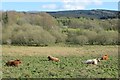
Cattle, Kinharvie
A field or two, then miles of conifers.
Image: © Richard Webb
Taken: 26 Apr 2015
0.18 miles
3
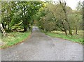
The driveway to Kinharvie House
Immediately after the gateposts is a bridge over the Glensone Burn.
Image: © Ann Cook
Taken: 3 Oct 2012
0.21 miles
4
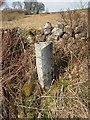
How Far to Killywhan?
This lichen covered milestone is barely readable. It says 5 miles to Killywhan but the distance to New Abbey is not discernible.
Image: © Iain Thompson
Taken: 26 Feb 2006
0.22 miles
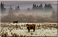
5
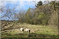
Sheep, Augenglas
Rough pasture amongst the conifers.
Image: © Richard Webb
Taken: 26 Apr 2015
0.23 miles
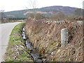
6
Old Milestone near Riddlebank, New Abbey parish
Milestone by the UC road, in parish of New Abbey (Nithsdale District), Riddlebank, just East of, and opposite track to house.
Inscription once read:-
: (Killywhan / 3) : : (New Abbey / 2¾) :
Surveyed
Milestone Society National ID: DG_NABW03
Image: © Milestone Society
Taken: Unknown
0.24 miles