IMAGES TAKEN NEAR TO
Kirkbean, DUMFRIES, DG2 8DL
Introduction
This page details the photographs taken nearby to DG2 8DL by members of the Geograph project.
The Geograph project started in 2005 with the aim of publishing, organising and preserving representative images for every square kilometre of Great Britain, Ireland and the Isle of Man.

There are currently over 7.5m images from over14,400 individuals and you can help contribute to the project by visiting https://www.geograph.org.uk
Image Map
Images are licensed for reuse under creativecommons.org/licenses/by-sa/2.0
Notes
- Clicking on the map will re-center to the selected point.
- The higher the marker number, the further away the image location is from the centre of the postcode.
Image Listing (44 Images Found)
Images are licensed for reuse under creativecommons.org/licenses/by-sa/2.0
Image
Details
Distance
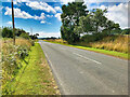
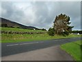
2
Looking towards Drumburn
This view is from the entrance to the car park at Drumburn Viewpoint.
Image: © Ann Cook
Taken: 3 Oct 2012
0.04 miles
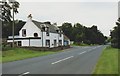

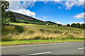
5
Looking across the A710 to Criffel Birks
This photograph was taken at the entrance to the car park at Drumburn Viewpoint.
Image: © Ann Cook
Taken: 3 Oct 2012
0.05 miles
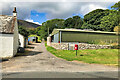
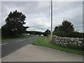
8
Looking north from Drumburn Viewpoint
This view looks towards the tiny settlement of Drumburn.
Image: © Ann Cook
Taken: 3 Oct 2012
0.06 miles
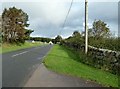
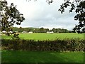
9

All is green alongside the A710 road in coastal Dumfries and Galloway
Trees, hedges and grassland line the route in to Drumburn.
Image: © James Denham
Taken: 21 Jun 2014
0.06 miles