IMAGES TAKEN NEAR TO
New Abbey, DUMFRIES, DG2 8DH
Introduction
This page details the photographs taken nearby to DG2 8DH by members of the Geograph project.
The Geograph project started in 2005 with the aim of publishing, organising and preserving representative images for every square kilometre of Great Britain, Ireland and the Isle of Man.

There are currently over 7.5m images from over14,400 individuals and you can help contribute to the project by visiting https://www.geograph.org.uk
Image Map
Images are licensed for reuse under creativecommons.org/licenses/by-sa/2.0
Notes
- Clicking on the map will re-center to the selected point.
- The higher the marker number, the further away the image location is from the centre of the postcode.
Image Listing (6 Images Found)
Images are licensed for reuse under creativecommons.org/licenses/by-sa/2.0
Image
Details
Distance
1
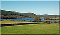
Loch Kindar View
Viewed from farmland on the Ardwall access road, the islands lie in the next square. The smaller island is a crannog. There's an old church tucked away on the other island. The far-off Waterloo Monument is just visible on the skyline.
Image: © Mary and Angus Hogg
Taken: 6 Oct 2018
0.10 miles
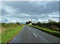
4
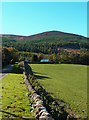
Knockendoch View
Knockendoch is an outlier of Criffel, which can be accessed from a path at the end of this road.
Image: © Mary and Angus Hogg
Taken: 6 Oct 2018
0.23 miles
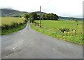
5
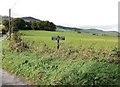
The sign for Ardwall Mains and Ardwall
The track to these properties can be seen on the left.
Image: © Ann Cook
Taken: 3 Oct 2012
0.24 miles