IMAGES TAKEN NEAR TO
Southwick, DUMFRIES, DG2 8AT
Introduction
This page details the photographs taken nearby to DG2 8AT by members of the Geograph project.
The Geograph project started in 2005 with the aim of publishing, organising and preserving representative images for every square kilometre of Great Britain, Ireland and the Isle of Man.

There are currently over 7.5m images from over14,400 individuals and you can help contribute to the project by visiting https://www.geograph.org.uk
Image Map
Images are licensed for reuse under creativecommons.org/licenses/by-sa/2.0
Notes
- Clicking on the map will re-center to the selected point.
- The higher the marker number, the further away the image location is from the centre of the postcode.
Image Listing (14 Images Found)
Images are licensed for reuse under creativecommons.org/licenses/by-sa/2.0
Image
Details
Distance

5
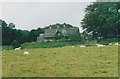
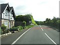
Shawfoot House
A Category B listed building.
Image: © Richard Sutcliffe
Taken: Unknown
0.20 miles
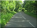
6
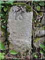
Old Milestone by the A710, Caulkerbush
By the A710, in parish of Southwick and Colvend (Stewartry District), Caulkerbush, set in dyke (wall) at back of pavement, South side of road.
Inscription reads:- : 16 : (To Dumfries)
Surveyed
Milestone Society National ID: DG_DFDBS16.
Image: © Milestone Society
Taken: Unknown
0.20 miles
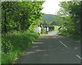
7
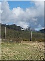
Mersehead
View across to Millbank Farm.
Image: © Andy Farrington
Taken: 17 Mar 2012
0.20 miles
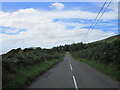
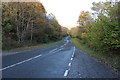
9
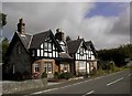
Houses in Caulkerbush
Two houses of an unusual style for this area.
Image: © Colin Kinnear
Taken: 10 Sep 2009
0.21 miles