IMAGES TAKEN NEAR TO
Park Place, DUMFRIES, DG2 7LS
Introduction
This page details the photographs taken nearby to Park Place, DG2 7LS by members of the Geograph project.
The Geograph project started in 2005 with the aim of publishing, organising and preserving representative images for every square kilometre of Great Britain, Ireland and the Isle of Man.

There are currently over 7.5m images from over14,400 individuals and you can help contribute to the project by visiting https://www.geograph.org.uk
Image Map
Images are licensed for reuse under creativecommons.org/licenses/by-sa/2.0
Notes
- Clicking on the map will re-center to the selected point.
- The higher the marker number, the further away the image location is from the centre of the postcode.
Image Listing (12 Images Found)
Images are licensed for reuse under creativecommons.org/licenses/by-sa/2.0
Image
Details
Distance
1
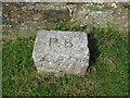
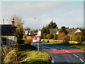
Old Boundary Marker by the A710, Maxwelltown parish
Parish Boundary Marker by the A710, in parish of Maxwelltown (Dumfries and Galloway Council), North of Priestlands, opposite Broomlands Lodge at edge of town.
Surveyed
Milestone Society National ID: DF_MXT02pb
Image: © A Weighill
Taken: 25 Jul 2011
0.06 miles
2
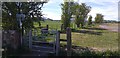
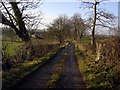
Five fields path
Start of the five fields path to Cargenbridge.
Image: © Colin Kinnear
Taken: 24 Apr 2020
0.07 miles
3
New Abbey Road
Tall hedges bound the estate houses on the main A710 road heading south-west from Dumfries.
Image: © Colin Smith
Taken: 4 Apr 2007
0.08 miles
4
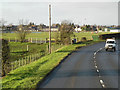
New Abbey Road, Dumfries
The A710, New Abbey Road, on the edge of Dumfries. Rugby ground on the left hand side of the road.
Image: © David Dixon
Taken: 14 Feb 2013
0.09 miles
6
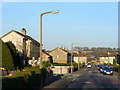
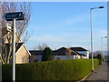
Hazelrigg Avenue, Dumfries
A housing estate in Broomlands, south-west Dumfries, with speed bumps to produce a more resident-friendly environment.
Image: © Colin Smith
Taken: 4 Apr 2007
0.12 miles
8
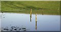
Flooded Area
A small flooded area at Priestlands Farm.
Image: © Colin Kinnear
Taken: 20 Dec 2008
0.21 miles
9
Track to Priestlands
The rough track which leads to Priestlands Farm now converted.
Image: © Colin Kinnear
Taken: 20 Dec 2008
0.21 miles
