IMAGES TAKEN NEAR TO
McKenzie Terrace, DUMFRIES, DG2 7AR
Introduction
This page details the photographs taken nearby to McKenzie Terrace, DG2 7AR by members of the Geograph project.
The Geograph project started in 2005 with the aim of publishing, organising and preserving representative images for every square kilometre of Great Britain, Ireland and the Isle of Man.

There are currently over 7.5m images from over14,400 individuals and you can help contribute to the project by visiting https://www.geograph.org.uk
Image Map
Images are licensed for reuse under creativecommons.org/licenses/by-sa/2.0
Notes
- Clicking on the map will re-center to the selected point.
- The higher the marker number, the further away the image location is from the centre of the postcode.
Image Listing (115 Images Found)
Images are licensed for reuse under creativecommons.org/licenses/by-sa/2.0
Image
Details
Distance

2

Troqueer Parish Church, Dumfries
Troqueer Parish Church (1770-1 & 1886-8) has two war memorial windows. The churchyard contains table stones, monuments & a Gothic mausoleum.
Image: © Chris Newman
Taken: 15 Oct 2005
0.06 miles

5
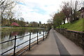
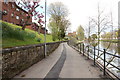
Riverside Walk
A workman cleans up litter on a footpath beside The River Nith in Dumfries.
Image: © Colin Kinnear
Taken: 2 Feb 2010
0.07 miles
7

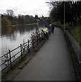
River Nith footpath
Footpath which runs beside the River Nith in Dumfries.
Image: © Colin Kinnear
Taken: 30 Apr 2018
0.09 miles
10
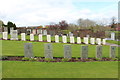
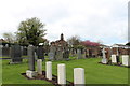
Troqueer Cemetery, Dumfries
Nearest grave stones are Norwegian.
Image: © Billy McCrorie
Taken: 17 Apr 2017
0.09 miles