IMAGES TAKEN NEAR TO
Dalswinton Village, DUMFRIES, DG2 0XU
Introduction
This page details the photographs taken nearby to DG2 0XU by members of the Geograph project.
The Geograph project started in 2005 with the aim of publishing, organising and preserving representative images for every square kilometre of Great Britain, Ireland and the Isle of Man.

There are currently over 7.5m images from over14,400 individuals and you can help contribute to the project by visiting https://www.geograph.org.uk
Image Map
Images are licensed for reuse under creativecommons.org/licenses/by-sa/2.0
Notes
- Clicking on the map will re-center to the selected point.
- The higher the marker number, the further away the image location is from the centre of the postcode.
Image Listing (12 Images Found)
Images are licensed for reuse under creativecommons.org/licenses/by-sa/2.0
Image
Details
Distance
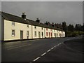
1
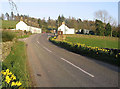
Dalswinton
The approach from the west.
Image: © Walter Baxter
Taken: 24 Mar 2007
0.01 miles
3
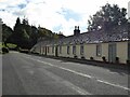
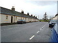
Cottages in Dalswinton
On the road from Auldgirth to Duncow.
Image: © Russel Wills
Taken: 29 Sep 2021
0.02 miles
4
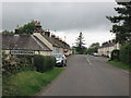
Dalswinton hamlet
What you see is what there is.
Image: © Peter Whatley
Taken: 20 Sep 2015
0.03 miles
5
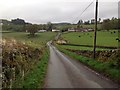
Start of Dalswinton Circular Walk
The start of the Dalswinton Circular Walk ( Core path 93 ).
Image: © Colin Kinnear
Taken: 16 May 2020
0.04 miles
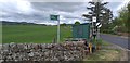
7
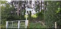
Start of Dalswinton Circular Walk
Start of Dalswinton Circular Walk, a 4.5 mile walk around the village.
Image: © Colin Kinnear
Taken: 16 May 2020
0.07 miles
8

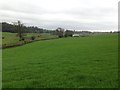
Copse in Field
A copse near the village of Dalswinton.
Image: © Colin Kinnear
Taken: 4 Mar 2010
0.11 miles