IMAGES TAKEN NEAR TO
Auldgirth, DUMFRIES, DG2 0XT
Introduction
This page details the photographs taken nearby to DG2 0XT by members of the Geograph project.
The Geograph project started in 2005 with the aim of publishing, organising and preserving representative images for every square kilometre of Great Britain, Ireland and the Isle of Man.

There are currently over 7.5m images from over14,400 individuals and you can help contribute to the project by visiting https://www.geograph.org.uk
Image Map
Images are licensed for reuse under creativecommons.org/licenses/by-sa/2.0
Notes
- Clicking on the map will re-center to the selected point.
- The higher the marker number, the further away the image location is from the centre of the postcode.
Image Listing (3 Images Found)
Images are licensed for reuse under creativecommons.org/licenses/by-sa/2.0
Image
Details
Distance
1
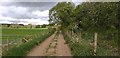
Dalswinton Circular Walk
On the Dalswinton Circular Walk heading towards the River Nith.
Image: © Colin Kinnear
Taken: 16 May 2020
0.16 miles
2
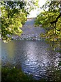
The River Nith
The graded embankment on the far side of the river supports the Dumfries to Kilmarnock railway line.
Image: © Russel Wills
Taken: 29 Sep 2021
0.22 miles
3
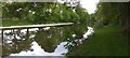
River Nith
The River Nith near Friars Carse.
Image: © Colin Kinnear
Taken: 16 May 2020
0.23 miles